| click here to find out more about:
|
To understand land judging you must first understand how a contest is set up
Preparing Field Sites
Each site should have colored flags to indicate
field boundaries of the area to be judged. The fields should be a
minimum of 100 feet x 100 feet in size, but it does not necessarily have
to be square. Two well-marked stakes should be placed 100 feet apart
for contestants to use to determine slope. These should be the same
distance above the ground and as much as possible with the normal slope
of the land. A hole or trench must be dug to expose the depth of
the soil profile. It is best to use string to mark off an area in
the trench as an "off limits area" that contestants use only to determine
topsoil thickness and soil depth. Representative topsoil and subsoil
samples should be available in boxes and appropriately marked. If
the soil is very dry, a water bottle should be available to moisten soil
samples.
The field condition card at each field will give you enough information to fill out the fertilizer portion of a land card also information needed for other portions of the land card. The land judging cards we will be discussing are single field cards. But for state and national contest you will be using a four field carbon self-grading card. (261K)
Texture
Soil texture refers to the relative proportion of sand, silt, and clay
particles in a specific soil mass. It is easiest to determine when the
soil is moist. Sand feels gritty when rubbed by the finger. Silt feels
slick or velvety. Clay is usually sticky and plastic when wet and when
pinched between the thumb and finger forms a flexible ribbon.
| click here to find out more about:
|
The surface texture is normally determined from at least plow depth or 6 inches, however, erosion may have removed the surface to such an extent that only 1 or 2 inches may remain. For contests, a boxed sample of surface soil and subsoil will be provided to judge texture.
In soils, several subdivisions of texture are recognized and are illustrated below. For land judging we recognize five texture categories represented by the middle column of the accompanying table.
Coarse-textured soils are loose, very friable, and the individual grains can be readily seen or felt. When squeezed between thumb and forefinger, it feels gritty and will not ribbon or stain fingers. Squeezed when dry, it will fall apart as pressure is released. When moist, a mold may be formed which is unstable and crumbles as the soil is handled.
Moderately coarse-textured soils feel gritty but contain enough silt and clay to make moist soil hold together. The individual sand grains can readily be seen and felt. Squeezed when dry, it will form a mold which breaks readily upon handling. If squeezed when moist, a mold can be formed which can be carefully handled without breaking. It forms no ribbon or very poor ribbon.
Medium-textured soils have a slightly smooth or velvety
feel when moist. Squeezed when dry, it forms a mold that will bear careful
handling. The mold formed by squeezing when moist can be handled freely,
without breaking. When the moistened soil is squeezed out between thumb
and forefinger, it will form a poor ribbon with a dull surface.
Moderately fine-textured soils usually break into clods
or lumps when dry. When the moist soil is squeezed out between thumb and
forefinger, it crushes with some effort. It will form a short (1 inch to
2 inch) well-formed ribbon with a shiny surface which will tend to break
or the ribbon will bend downward. The sandy clay loam texture has a slightly
gritty feel when moist.
Fine-textured soils form very hard, massive lumps or clods
when dry and are quite plastic and sticky when wet. When the moist soil
is squeezed out between thumb and forefinger it crushes with considerable
effort and will form a long (2 inch+) ribbon which will support itself.
The sandy clay texture may also have a slightly gritty feel when moist.
If the measurement is 40 inches or greater the hole
is deep.
If the measurement is between 20 and 40 inches the
hole is moderately deep.
If the measurement is between 10 and 20 inches the
hole is shallow.
If the measurement is less than 10 inches the hole
is very shallow.
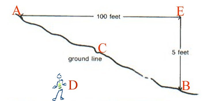
If elevation fall is less than 1 foot the slope
is nearly level.
If elevation fall is between 1 and 3 feet the slope
is gently sloping.
If elevation fall is between 3 and 5 feet the slope
is moderately sloping.
If elevation fall is between 5 and 8 feet the slope
is strongly sloping.
If elevation fall is between 8 and 15 feet the slope
is steep.
If elevation fall is greater than 15 feet the slope
is very steep.
Land Capability Class
The highest red number to the left of the boxes
will be the number you put for land capability class.*
*Different combinations of factors can cause the land class to go lower. We will discuss these combinations later.
|
Conditions that will not be used in contest: |